Walkers who fancy stretching their legs on one of England’s national trails can now get a visual preview of their route.
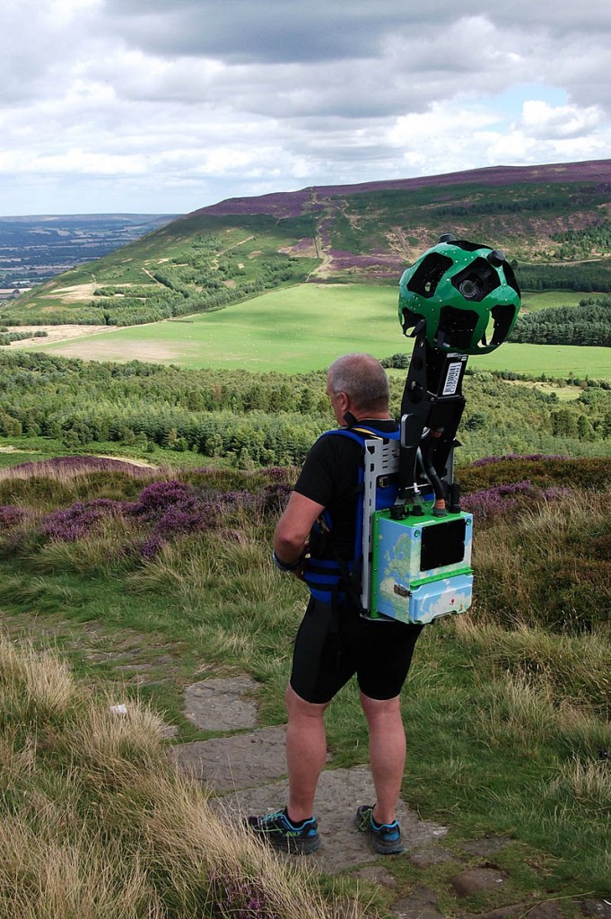
Volunteers used a Google Trekker backpack camera to record the route of the Cleveland Way through the North York Moors national park.
The images were released over the festive season and can now be seen on a dedicated site in the Google Street View format.
The entire 109-mile Cleveland Way national trail is now live following the mapping exercise using a special elongated camera and computer equipment mounted in the backpack as part of the Google Trekker loan programme.
It took volunteers from the Hardmoors ultrarunning team the equivalent of 13 full days within a seven-month period to walk the length of the trail carrying the 23kg (51lb) backpack.
Capturing the images took time as the team could only use the Trekker on fine, bright days and they needed to ensure the camera kit remained upright as they walked slowly along, even when faced with low branches and scrambling over challenging terrain.
The image sequence has since been stitched together to provide viewers with panoramic vistas along the Cleveland Way, which stretches from Helmsley across the North York Moors to Saltburn-by-the-Sea before re-entering the national park and then following the coastline down to Filey.
Part of the route will also be familiar to Wainwright’s Coast to Coast walkers, as the two trails coincide for some distance.
Jon Steele of Hardmoors said: “It is great to see the project going live especially as there were several challenging sections when we were walking with the Trekker including scrambling up the Wainstones and ducking down low enough under trees and hedges.
“However there were many lighter moments particularly when we were treated like celebrities as we walked through Scarborough to applause from visitors, after news of the Trekker project had been released.
“Plus there was the time when a group of children thought I was strapped to a rocket and about to fly. We have never had so many photographs taken of us.”
Malcolm Hodgson, national trails officer, said: “It is fantastic to harness the power of Google Street View in this way.
“Taking a virtual tour of the trail not only showcases the beauty of the Cleveland Way but it can also be a valuable planning tool, particularly giving reassurance to novice walkers when they’re looking to stride out on a section of the route.
“Local businesses can also benefit as they can use the images on Street View to help provide directions and information for visitors.”
The Google Street View images of the route include the moorland when its heather is in full bloom and it becomes a sea of vibrant purple. Visitors can also see images of the section of the trail that opened this summer, as part of the England Coast Path launch, offering a new vantage point of the fishing village of Staithes.
Other highlights are the scene out from Sutton Bank that author James Herriot claimed was ‘the finest in England’, the sandstone crags of the Wainstones towards the north-western edge of the national park, and the views from the highest point at 454m (1,490ft) of the North York Moors on Urra Moor. The historical sights of Rievaulx Abbey and Whitby Abbey have also been captured on the Google Trekkers.
The Cleveland Way runs for 175km (109 miles) in a horseshoe loop across much of the North York Moors national park between Helmsley and Filey. The coastal Cleveland Way follows part of the England Coast Path, which will be 4,500km (2,795 miles) long when it is completed in 2020.
The trail is managed by the North York Moors National Park Authority and Redcar and Cleveland Borough Council.
The Cleveland Way on Google Street View can be found on the National Trails website.


David, Thornton le Dale
01 January 2017Sorry to sound a spoilsport but I'm not keen on this. The outdoors is the place we can get away from technology and Google Streetview etc. Part of the challenge of the Cleveland Way is the navigation although it's well signposted anyway. For me this is a shame. Others may disagree....
Paul HETHE
02 January 2017How sad that we need something like this, what is wrong with learning to read a map and using your brain etc just think a group of people walking using an I pad to show them where to walk, it is supposed to be an Adventure into the wild.
Richard Fairhurst
03 January 2017I hope Google paid these volunteers in return for them contributing hours of labour to Google's for-profit website.
Better to contribute photos to geograph.org.uk and surveying to openstreetmap.org - both are copyright-free (well, strictly speaking, openly-licensed) and not for profit. Anything you contribute to Google can only be used by Google.
Bob
03 January 2017Take a look at grough's own new mapping, grough map, which uses several open sources including openstreetmap: http://geo.gy/
Bob, editor
Andrew Baynes
05 January 2017In response to the first two comments – with respect, I disagree. There are a number of advantages to this I can see:
1. It makes the trail 'accessible' to those of limited or no mobility. Whilst I agree that it would be much better to be experienced in real life, the opportunity for those groups to experience it at least vicariously is a positive
2. It is useful as an aid to allow people to see that it's not too 'scary'. Those of us that go out into the hills and the countryside know what we're in for. Those that never had may find the unknown nature of it off-putting. This will allow them to understand the scope and extent of what they're signing up for (notwithstanding that it's only ever sunny on this view by the sound of things!)
3. Far from it being 'sad'– in terms of teaching navigation, this is a great training aid. Whilst it would be great to be able to teach kids navigation out in the literal field every time, logistics preclude this. However, this is an opportunity to find a view and then to ask kids to use a map and decide what should be to the East of that view. Once they've determined that – rotate the view and see if they're correct.
Yes, in an ideal world, this would be an open-licence. However, at least it's freely accessible, and no licence is required for everyday use.
My thanks to those that gave up their time to walk the route.
Andy