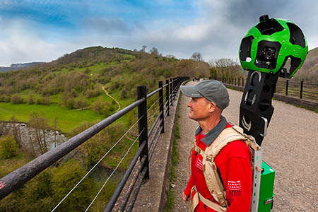
A ranger with the Trekker camera on the Monsal Trail
A national park has become the first in Britain to offer users a virtual off-road tour of its routes using Google Street View.
The online service is better known for its street-level views of the roads of the UK, but now computer users can see selected Peak District trails through Google’s website.
The images were taken by national park volunteers using Google’s Trekker cameras strapped to their backs.
Routes include the Monsal Trail, Tissington and High Peak Trails. There are also views of Stanage Edge near Hathersage.
Peak District National Park Authority chief executive Jim Dixon said: “It is our ambition that, by being on Google Street View, more people will enjoy the wonders of this protected and special landscape.
“Once people see it, I am sure they will be inspired to come and stay for a few days to explore first-hand what they have experienced online.
“The national park covers an area of 555 square miles so it was impractical to film every inch for people to view. Instead we have selected some of the highlights.
“These are the trail areas where we offer ranger-led walks, family activities and cycle hire and bike maintenance, so there are lots of ways for people to enjoy and experience what the national park has to offer.”
The equipment captures 360-degree imagery in public locations. It was taken to locations the Google Street View car can’t reach during filming in the summer.
Google’s Emily Clarke said: “We’re excited that the Peak District will be using the Street View Trekker so more of us can experience its famous trails and views from wherever we are.”
The Peak District Trekker images are now live. Examples include Stanage and Monsal.
Sheepy
06 November 2014Great news for the lazy lardies!
They can now go walking in the countryside, without actually doing any walking. At least they won't be out there dropping their chocolate wrappers on the ground.
PurpleHaze
09 November 2014If only Google would focus on their other street view projects they claimed they would do but dropped.