Britain’s official meteorologists have introduced a new detailed service for hillgoers.
The Met Office now offers summit forecasts for more than 500 hills across the UK, adding to its existing regional mountain forecasts.
A Met Office spokesperson said: “The new summit forecasts take into account the very different types of weather you are likely to experience at these locations helping walkers, ramblers and climbers plan their trip, walk or expedition.
“The tailored information provides forecast information on weather, wind, temperature and visibility in easy-to-read symbols, with additional information on feels like temperature, humidity, UV index and the chance of rain out to five days ahead.
“Unique to the Met Office the summit forecasts also provide easy access to severe weather warnings that may be in force, helping walkers prepare, plan and protect themselves from the impacts of potentially severe weather.
Derrick Ryall, head of the Met Office public weather service said: “Mountains can be inhospitable and dangerous places for the ill-prepared.
“From one hour to the next, from one hill to the next, they can exhibit a dramatic variation in weather conditions.
“These local and accurate forecasts from the Met Office allow walkers and climbers to be more weather aware and better prepared for the conditions that can be experienced in the hills and mountains of the British Isles.”
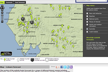
The website has maps with the available peaks marked. Clicking on them brings up the forecast for that mountain or hill, though there are quirks. For instance, Scafell is included, but not Scafell Pike, England’s highest mountain. Blencathra is on the system but its big brother Skiddaw isn’t.
The Met Office recommends hillgoers use the summit service with the mountain area forecasts, which give a more detailed prognosis for several upland regions in Britain.
Walkers and climbers also have access to the Mountain Weather Information Service, and the sportscotland Avalanche Information Service which has now begun its full winter service.
The avalanche risk in both Lochaber and the northern Cairngorms is high, with other Scottish mountain areas having considerable avalanche risk.


Statler
15 December 2012The Skiddaw thing is easy. It's cloudy. The end...
stigofthenest
15 December 2012aww statler... i feel for you.. ive been up skiddaw once.. 360 degree vis - though it was bitingly chilly
Paul B
15 December 2012Yes, When I worked at Capel Curig, they said if you can see Moel Siabod its about to rain, if you cant its raining!
Seriously though another useful tool, MWIS is the first point of reference for me though
Stephen Green
15 December 2012Re the Blencathra / Skiddaw point. Common sense needs to be applied. One can assume that the data for a particular summit would apply to surrounding fells but allowing for variablity due to height differences (for example, knowing the cloudbase, working out whether a neighbouring summit is in cloud or not)