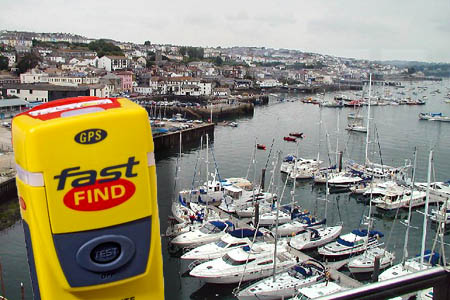
The distress signal was relayed to the Coastguard in Falmouth. Main photo: Chris J Dixon CC-BY-SA-2.0
A man was rescued from an antipodean wilderness, thanks to coastguards in Cornwall, 11,000 miles away.
Chris Painter activated his personal locator beacon when he injured his knee on a 10-day trip in the Kahurangi national park in New Zealand.
The retired teacher’s SOS signal was picked up by the Maritime and Coastguard Agency in Falmouth, and staff there alerted the New Zealand rescue services, who went to the expat’s aid.
Mr Painter, 61, had bought his McMurdo Fast Find PLB in the UK 10 years ago, two years before he emigrated. Because it was still registered in the UK, Falmouth Coastguard was alerted by the signal from the global Cospas-Sarsat emergency satellite system.
Mr Painter, who used to live in Ilkley, West Yorkshire, activated the pocket distress beacon when he could not get a mobile phone signal in the remote national park in the North-West of the country’s South Island.
He is now recovering at his New Zealand home and walking with the aid of crutches. He said: “I bought this Fast Find PLB ten years ago and I always carry it whenever I venture in to remote locations. I was extremely grateful to have it with me during my fishing trip in the Kahurangi national park, where I came into difficulty.
“I would like to thank the rescue services for their amazing help and speed – just one hour and 20 minutes after activating my Fast Find PLB a rescue helicopter landed and I was being attended to by a paramedic.”
PLBs such as the Fast Find can now be used in the UK for outdoor activities. Although PLBs have been used on land in numerous countries around the world for many years, in January 2012 rules allowing PLBs to be used on land in the UK came into force, in addition to maritime and air use.
Mr Painter’s PLB also transmitted a homing signal, to enable search and rescue teams to home in on the beacon once in the vicinity. The Fast Find PLB has a 50-channel GPS receiver to give precise location co-ordinates.
Margaret
15 March 2012I wonder when we will cease to be surprised by the use of radio technology.
Marconi sent signals across the Atlantic over 100 years ago and we have been using satellites since the 1960s.
I suspect that the emergency signal transmitted on 406 MHz is digital and not SOS, which is a Morse Code emergency signal. Morse is now primarily used by Amateur Radio license holders.
Outdoorsman
15 March 2012Thank you for the opportunity to comment:
To add an important component to the story, it should be mentioned that HM Coastguard do not themselves pick up the signal from the satellites. In this case, the gentleman activated his Personal Locator Beacon (PLB) and the databurst, complete with GPS-derived position that should have been correct to within 120 metres, was then relayed via the New Zealand tracking station to the UK Mission Control Centre (UKMCC) in NE Scotland. There, the MCC Operator processed the information and distributed it to, amongst other addressees, MRCC Falmouth. He will also have quickly sent the Emergency Point of Contact (EPOC)information to New Zealand, using the terrestrial Cospas-Sarsat communications networks, via MCCs in France and Australia. The N Zealand SAR authorities then used the UK-coded beacon's position and EPOC information and tasked the appropriate SAR resouces and the casualty was efficiently evacuated to hospital. The UKMCC is co-located with the UK Aeronautical Rescue Co-ordination Centre at RAF Kinloss, in Moray. Thanks.
Margaret
16 March 2012A very useful and interesting description of the process by Outdoorsman.
Bye the way - in the year of the 100th anniversary of the sinking of the Titanic - the Morse emergency call prior to 1912 was GQD. This was the call the two radio operators (Marconi Men) sent for the initial distress call. They then decided to try the 'new' SOS call which they used until a few minutes before the ship finally sank.
SOS does not stand for Save Our Souls - it doesn't stand for anything - it is a combination of letter sounds that is easily identified by the ear while using Morse Code.