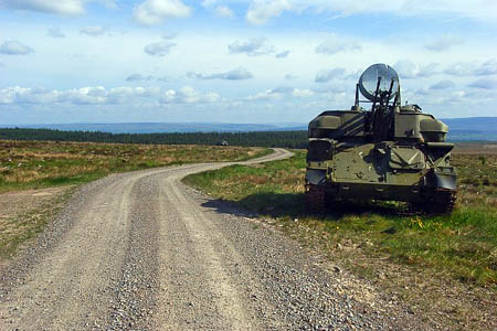
The Ministry of Defence will jam sat-nav signals in the remote north Pennines during exercises later this year.
Ofcom, the official Government body covering radio communications, warned that Global Positioning System signals will be jammed around RAF Spadeadam on the Cumbria-Northumberland boundary.
Walkers and outdoor enthusiasts may find their hand-held electronic devices unable to give a reading during the exercises, which will take place between 28 November and 9 December.
Ofcom said an area within 5km (3 miles) of the military base could be affected. Walkers will need to resort to traditional map-and-compass navigation while the jamming, which is timed to occur between 9am and 4pm, is taking place.
The jamming is likely to affect any GPS units up to 5km from Berry Hill in the Spadeadam Forest. The Hadrian’s Wall national trail lies 2km further south and there are few public rights of way in the jamming area, though there are tracts of Countryside and Rights of Way Act open access land within the stated radius, including Side Fell to the West and White Side and Deer Hill in the Kielder Forest Park to the East.
RAF Spadeadam covers the biggest area of any of the air force’s bases in the UK and is home to the Electronic Warfare Tactics Range. It was also the test and launch site for Britain’s aborted Blue Streak missile project.
- A similar jamming exercise off the Scottish coast had to be abandoned earlier this week after fishing vessel skippers complained it was putting them in danger.
The Royal Navy said it had issued warnings and that Coastguard officers had also been transmitting messages about the upcoming GPS jamming, but vessel operators claimed they had been caught unaware by the exercises which were part of NATO’s Exercise Joint Warrior, which continues for another week.

Barry
12 October 2011Please check the above photo you are using with the mod as we don't use that anti aircraft weapon and don't think you should be posting it on line.
Richard Webb
12 October 2011It has been "online" for 3 years now.