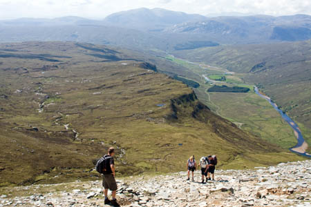
Walkers in the northern Highlands have enjoyed fine, dry weather
Britain’s weather continues to break records, with the announcement today that the country has had its driest first six months of any year since 1929.
Walkers who had to contend with the highest rainfall ever recorded in Cumbria in November last year, and the heaviest snowfall in some areas since the 1960s have now been blessed with some of the driest conditions underfoot for 80 years.
Last week, the British Mountaineering Council warned of the increased risk of wildfires.
The Met Office today released figures showing that, between January and June, the average rainfall in the UK was just 356.8mm. During the 2009 Cumbria floods, Seathwaite recorded 316 mm of rainfall in 24 hours and many upland areas of the county had more than 400mm of rain in a three-day period.
The long term average rainfall for the UK between January and June is 511.7mm.
In contrast with last year, the UK has had its second driest period for 100 years. The Met Office said this is because of a lack of Atlantic weather systems, which usually cross the UK bringing bands of rain, especially to western regions.

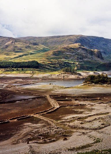
The hamlet of Mardale Green, flooded by the Haweswater reservoir in 1935, is now reappearing. This photo, by Janet Richardson, shows the hamlet during the 1996 drought. CC-BY-SA-2.0
The drier conditions have affected water resources in some areas. Haweswater reservoir in the Lake District has dropped low enough to reveal the old hamlet of Mardale Green, which is normally submerged. Parts of Cumbria that suffered the worst floods in memory in November now face the prospect of a hosepipe ban.
Barrie Clarke, communications director at Water UK, the water industry representative, said: “These figures paint a graphic picture of why reservoir levels in the west are so low by comparison with normal years. During such a dry spell it makes sense to use water wisely wherever you live.”
The British Mountaineering Council issued a warning last week, saying: “With the recent spell of hot weather, the risk of wildfires has risen. In the past few weeks a number have already been reported across the moorlands of England and Wales, particularly in Yorkshire and the Peak District and wildfires are expected to be a serious problem over the summer months.”
The fire severity index is expected to rise to high on Saturday in large parts of England – one stage below the exceptional level that triggers the closure of Countryside and Rights of Way Act open access areas – before falling back to lower levels.
The Met Office said: “Over the weekend and into next week, further rain is expected towards northern and western regions, with some significant amounts. Dry weather is expected to continue over southern and eastern parts of the UK, however, there is the risk of a thunderstorm.”
Advice from the BMC for avoiding starting wild fires is:
- If you smoke on the moors, stub your cigarette out on a stone or on the sole of your shoe and take the cigarette butt home or use one of the special pouches provided by organisations such as Moors for the Future
- Camping isn’t allowed on any open access area unless the landowner has specifically given you permission, so don’t camp, and definitely don’t start a campfire. Don’t light barbecues in a high-risk area
- If you see a fire, call 999 immediately, give them a general location and try to contact the ranger service or local access authority as soon as possible.
Dave Gibson, chief officer of the Mountaineering Council of Scotland, adds: “The advice from the BMC doesnt apply in Scotland. You don’t need the landowner’s permission to wild camp. The MCofS website has the correct information.”
David Gibson
30 June 2010Thanks for printing the clarification. From being out in the Scottish hills recently it's was clear that many of the lochs are at very low levels. Examples include lochs such as Glascarnoch, a'Bhraoin, Ericht and Treig. Farmers in the east of Scotland are talking up berry and tatty prices due to high irrigation costs, not that that's a surprise of course.
Amos Germ
04 July 2010While it poured down today, the English jobsworths will soon be "closing" the hills to protect the moors from spontaneously combusting hillwalkers. Meanwhile the low quality persons will still be chucking their fagends out of car windows.
Sadly the Tweed is at a record level and there is even less water between us and such madness.
Davy Stephenson
28 August 2012The drought in which your picture was taken here was actually in 95, nice picture of the village green, taken from just above Grove Brae ruins in thef oreground looking towards Chapel Hill Bridge.
The howe island on the right and speaking crag beyond that with its pine trees at the far shore.
Davy.
www.mardale.green.talktalk.net