Walks
High-level thrills lead to the top of Pillar
Some Lakeland mountains draw you to them. They evoke a distant history and attendant mystery and whisper ‘climb me’: Helvellyn, Blencathra, Skidda...
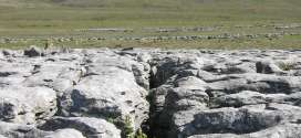
A short trip to Moughton's alien landscape
Distance: 12km (7½ miles) Ascent: 340m (1,115ft) Time: allow 3½ hours Map: Ordnance Survey Explorer, OL2, Yorkshire Dales southern and western areas or Harvey’s Superwalker Yorkshire Dales Three Peaks Note: grough routes should be used in conjunction with maps, a compass and other navigational aids.
Sea to Sea: we follow Wainwright from Coast to Coast
Britain has 15 national trails – long-distance paths and bridleways that offer a challenge to anyone who wants to walk, cycle or ride a horse over linked rights of way.
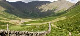
Harter Fell - the quiet way
Harter Fell from LongsleddaleNote: groughRoutes should be used in conjunction with maps, a compass and other navigational aids.
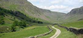
Great Gable, the way the climbers see it
Great Gable, Green Gable and Base Brown from SeathwaiteNote: groughRoutes should be used in conjunction with maps, a compass and other navigational aids.
Solitude beckons on the Howgills' velvet slopes
Quite unlike their near cousins the Yorkshire Dales and the Cumbrian Fells, the velvety bumps of the Howgill Fells have a character all of their own.
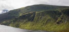
Border post: White Coomb and the Grey Mare's Tail
Mention hillwalking and Scotland in the same sentence and most people automatically think of the Highlands: munros, romantic-sounding Gaelic names, precipitous edges.
Calderdale's moorland green lungs
Distance: 16.6km (10⅓ miles)Ascent: 340m (1,115ft)Time: allow 5 hoursMap: Ordnance Survey Explorer, OL21, South PenninesNote: grough routes should be used in conjunction with maps, a compass and other navigational aids.
The West Highland Way: 95 miles of pain, pleasure, plasters and pasties
The walker setting forth on the West Highland Way is embarking on a trip through history. Not only will his or her route pass through scenes of bloody...
Ingleborough's little corrie
Map: Ordnance Survey Explorer OL2, Yorkshire Dales southern and western areas or Harvey’s Superwalker Three PeaksNote: groughRoutes should be used in conjunction with maps, a compass and other navigational aids.
Pages
Most recent
Commented
2 Record-breaking runner Tom Hollins prepares for longest challenge: the Lakeland Round
3 Scrambler airlifted from Lakeland mountainside after tumbling 160ft
4 Rescuers pay tribute to David Parrish who died on Cape Wrath Trail challenge
5 Teens rescued after failing to find Priest's Hole during Storm Dave
6 Company behind Dragon's Back Race and Cape Wrath Ultra goes out of business
7 Two rescue teams and two helicopters go to aid man after 300ft fall on Helvellyn
8 Pre-pack administration deal allows Alpkit to continue trading
9 Ex-gamekeeper Racster Dingwall fined for raptor persecution in first case of kind
2 Rescuer injured as team battles Storm Amy 80mph winds to reach injured walker (5)
3 New West Yorkshire national nature reserve will include Brontë moorland (4)
4 Rescuers offer guidance after callouts to Lakeland wild campers (4)
5 Rebuild of Culra Bothy will be charity's most expensive project to date (3)
6 Work on 'dreaded' stretch of Coast to Coast Walk paves way for National Trail opening (2)
7 Teens rescued after failing to find Priest's Hole during Storm Dave (2)
8 Happy 60th birthday to the Pennine Way (2)
9 The Angry Corrie founder Dave Hewitt dies, aged 64 (2)