More than 25 years ago a party of 20 people from the Retired People’s Club were walking on the Berwyn Mountains in northern Mid Wales.
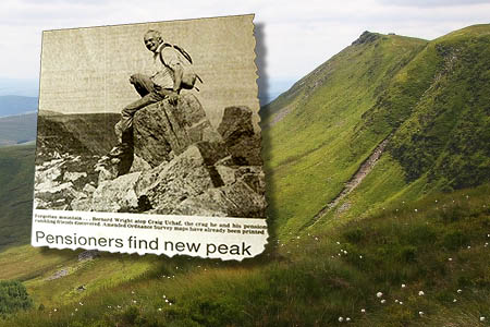
The party was being led by Bernard Wright, a former motor oils scientist from Tarvin in Cheshire. As they headed up to the main Berwyn ridge they were confronted by a peak that was absent from their Ordnance Survey maps.
Bernard and his friends were standing beside the trig pillar on Cadair Berwyn looking south toward Moel Sych.
Both hills nowadays are given the same metric height of 827m. When Bernard looked south the map told him that Moel Sych was 1ft higher at 2713ft, compared to the 2712ft for Cadair Berwyn. But something was wrong as the map indicated that these two summits were the highest in the Berwyn, but between the two was another hill, a hill that looked higher, but was not shown as such on any map.
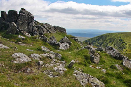
The group visited the unknown and seemingly non-existent hill and Bernard sat on its highest rock and peered out over the top of Cadair Berwyn and Moel Sych.
This hill was definitely higher, but why wasn’t it shown as such on the map? As the friends descended, they chatted about the hill and someone proposed that they should name it Berwyn Wright, a Welsh friend in the party suggested the name Craig Uchaf and, although an appropriate name it has never caught on.
Research conducted for the ‘Y Pedwarau’ hill list (published by Europeaklist in 2013) revealed that the peak is known to some of the local farmers and shepherds as Craig Berwyn, a name that already appears on the Ordnance Survey map.
Bernard reported his find to the Ordnance Survey and was told that the two 827m peaks were the highest points for miles around. Dissatisfied with this answer, Bernard persevered and gave detailed co-ordinates for the peak, which prompted the OS to examine their large-scale mapping on which was found a tiny 830m ring contour that did not appear on the publicly available 1:50,000 and 1:25,000 maps.
The news of Bernard’s ‘new mountain’ hit the headlines with articles appearing in The Guardian as well as the Ramblers Association magazine, and soon the tiny 830m ring contour appeared on the new OS 1:25,000 Explorer map.
However, one thing the Ordnance Survey never did was to give the mountain an accurate absolute height, relegating it to among the few principal Welsh mountains that do not have definitive values for elevation.
As the summit is made up of a number of embedded rocks, all jutting out of the ground, the height could well be higher than thought. If an accurate height was given to the mountain, it would also be the culmination of a story that first started over 25 years ago when Bernard Wright and his friends came across a mountain that seemed not to exist.
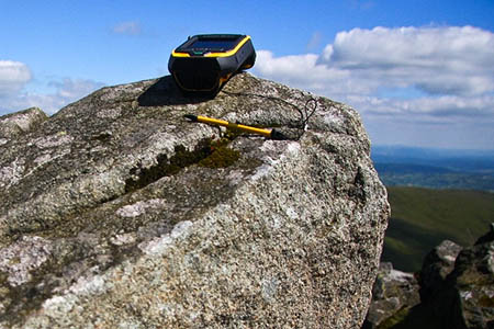
Enter a hill sleuth with a new piece of equipment: the Trimble GeoXH 6000.
This fancy piece of equipment only weights 2lb and can achieve accurate height results in no more than five minutes. The hill sleuth in question is Myrddyn Phillips who is a member of G&J Surveys, those infamous independent surveyors who have discovered new mountains and dethroned Munros.
Myrddyn said: “The Trimble Geo 6000 is accessible to the G&J team and is proving to be a great piece of equipment to ‘screen’ hills with, as its precision is +/- 0.15m when compared to our Leica GS15 whose accuracy is +/- 0.05m when we collect upwards of two hours of data.”
“Therefore any hill measured with the Trimble whose height is close to a recognised threshold, such as 2,000ft or 3,000ft can then be surveyed to a higher degree of accuracy with our Leica equipment.”
However, the hill was more than a lump of rock that Myrddyn wanted to place a bit of surveying equipment on top of. It held an emotional tie for him as he had scattered some of his father’s ashes from its highest point and the height of the hill had intrigued him ever since he had read the article about Bernard Wright’s new mountain years ago in the late 1980s.
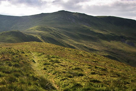
The trip to survey Craig Berwyn proved quite an expedition as Myrddyn wanted to survey all eleven hills and their respective cols that make up the Maen Gwynedd Horseshoe.
This is an extended walk he had done on many occasions but never with the intent to carry out so many surveys. The hill sleuth told grough: “Although I wanted to survey every hill on the horseshoe it was the high point of Craig Berwyn that really interested me.”
He set out on 21 June as the surveying expedition would require many hours to complete and with the weather settled and the notorious peat paths of the higher Berwyn dry, it meant that he shouldn’t encounter any undue problems.
As the highest rocks of the Berwyn were approached a slight breeze picked up, although it wasn’t strong enough to worry Myrddyn as he placed the Trimble on the very highest point of the mountain range, the same spot that Bernard Wright had sat and peered out over the two adjacent and lower peaks all those years ago.
Mr Phillips said: “It was ideal as the breeze was only light and the view from the summit took in all the higher Snowdonia peaks to the west as well as the lower hills towards the English border.”
As he arrived back at his car the expedition had taken more than 12 ½ hours to complete.
Ten minutes of summit data were collected by the Trimble GeoXH 6000 and later post processed, giving a result of 831.98 +/- 0.15m. So over 25 years since Bernard Wright first discovered the mountain its true height is now known, and at 832m it seems that little 830m ring contour on OS maps is hiding quite a substantial rock under it.
Further details of this survey and others can be found on Myrddyn’s blog.
Eryl Selly
01 July 2014This mountain has long held special memories since I first climbed it as a lad in the late 1960's and I had thought of asking that my ashes be scattered up there but since have decided to let the family do what they want with me! I was unaware of the 1980's article. Well done Mr Phillips.
madcarew
08 July 2014Craig Berwyn is the best looking hill in the range too.