Hillbaggers who think they have summited all England’s mountains will have to think again.
A new 2,000-footer will join the list of hills topping the magic mountain mark after a recent survey by a trio of amateur hill sleuths.
Thack Moor in the northern Pennines is 2,000 feet high – just.
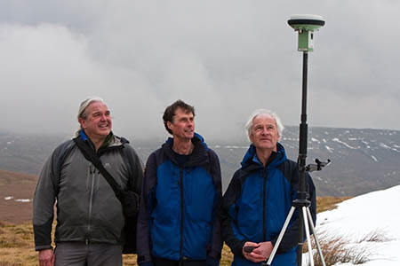
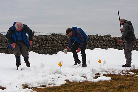
Measurements by John Barnard, Graham Jackson and Myrddyn Phillips using high-tech GPS equipment show the otherwise unprepossessing grassy Cumbrian hill tops out above the official mountain height, by less than an inch.
Ordnance Survey, the Government mapping agency, confirmed the data collected by G&J Surveys, as the trio is known, on two visits to the hill put Thack Moor at 609.62m, just two centimetres above the metric equivalent of 2,000ft.
The authors of hill lists have agreed to amend their books to reflect the addition, and Ordnance Survey said it will amend its maps to record Thack Moor’s height as 610m.
Although amateurs, G&J Surveys’ trio of hillwalkers use the most up-to-date satellite equipment to collect height data from American Global Positioning Satellites. The data is then run through sophisticated software by Ordnance Survey to ensure maximum accuracy.
Mark Greaves, an OS geodetic analyst, said: “Essentially when they measure a hill or mountain and their result contradicts what’s on our map they send me their GPS data to check and re-process.
“I run the data through some very high end scientific GPS processing software called Bernese.
“The same software and analysis techniques are used to compute the coordinates of our OS Net stations. Given a suitable amount of data the software can compute GPS station coordinates to 2mm in plan and 6mm in height. OS Net is the national positioning infrastructure.”
The trio made two separate visits to Thack Moor when it became obvious the result was going to be so close.
Mr Greaves said: “For the Thack Moor surveys this external check showed that both times the height was accurate enough to be confident that it really was just over 2,000ft.
“The fact that the result is so close to 2,000ft is what prompted to me to ask for a second survey of the hill.
“Now two independent surveys using high quality GPS data, from different equipment, and the best possible computation and analysis have both shown that Thack Moor is indeed just over 2,000ft.
“The combined accuracy of the height measurement from both surveys was plus or minus 2cm so, even erring on the side of caution, it is still 2,000ft and it’s equally likely it could be 2,000ft and 4cm.
“Our cartography department have been informed of the change at Thack Moor – the height goes from 609 to 610 – and we hope to have the change in our digital data soon.”
Thack Moor will lose out in one respect: it will no longer be classed as a Dewey, an English, Welsh or Manx hill between 500m and 609.6m in height with a minimum of 30m of drop in a list compiled by Michael Dewey.
It will, however, be added to two lists in the complicated world of hill heights. The Cumbrian moor will become a Hewitt – the acronym for Hill in England, Wales or Ireland over Two Thousand feet which must have a minimum prominence of 30m. List keeper Alan Dawson has agreed to add the hill to his compilation.
And Anne and John Nuttall, keepers of a set of hills with the slightly different criteria of 2,000ft height and 15m drop, also said they will add the hill to their Nuttall list.
Anne Nuttall revealed the pair have already made it to the summit of Thack Moor.
She said: “John and I have already ticked Thack Moor off – well in advance of Graham, John and Myrddyn.
“We didn’t know it was a two-thousander then of course, but in May 1998 we did a north Pennines backpack.
“We started from Appleby and walked via Dufton up High Cup Nick and camped on Backstone Edge.
“On day two we continued over Knock Fell, Great and Little Dun Fells, Cross Fell, Melmerby Fell and Fiends Fell and camped on the summit of Black Fell.
“Day three was over Thack Moor then on to Croglin and to Armathwaite and back by train.”
The trio of amateur surveyors have worked with Julia Bradbury to find Wiltshire’s highest point; elevated Glyder Fawr to 1,000m status, and demoted Sgurr nan Ceannaichean from the munro list.


Bob Whittall
04 April 2013Shouldn't Thack Moor now be added to Bridge's list of two-thousanders, as a "top" rather than a separate mountain?
Charles Britten
05 April 2013In addition to the above, they have also managed to get Beinn a' Chleibh demoted from the Munros, although it took the SMC a year to confirm this as they and the Munro Society evidently do not talk to each other.
Myrddyn Phillips
05 April 2013Bridge's Tables was an excellent list during the 1970's and I'm sure if George was with us today he would promote Thack Moor to his 2,000ft list. If you're interested in the surveying we do why not follow GJ Surveys on Facebook and get the latest news when it happens.
Trevor Prew
18 April 2013If the survey team are looking for something else to do, I suspect the true summit of Burnhope Seat (nuttall walk 10.1) is not at the trig point as described in the book. The point 200m west looks higher, was 2m higher according to my GPS and is also marked as higher on the 1:50000 OS map. I raised this with John Nuttall, but he said he used a different map.
John Barnard
18 April 2013We have already been to Burnhope Seat. The trig point is at NY 78790 37535 but the actual summit is about 1.5m higher and 350m to the west of the base of the trig and is at NY 78445 37561. If you need to know latest data about hills then go to www.hill-bagging.co.uk. All the data there has our survey data included.